176/220

 Download Photo
)
)
)
)
)
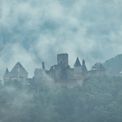
There's no such thing as bad weather. Taken from Gringlay Vista Point, Bourscheid, Luxembourg. The Escapardenne Lee Trail hiking path goes to this viewpoint.
- Palette
- Created on
- Saturday 24 July 2021
- Posted on
- Monday 1 November 2021
- Tags
- Ardennes, camping, castle, cloud, clouds, country:Lëtzebuerg, country_code:lu, county:Canton Diekirch, Gringlay, hamlet:Bourscheid-Moulin, hiking:Escapardenne Lee Trail, hiking:GR 57, hiking:Sentier du Nord, hiking:Vallée de l'Ourthe-Gilsdorf, postcode:9164, river, road:N 27, Sauer, tourism:Gringlee, village:Lipperscheid
- Albums
- Visits
- 1875
- Location
- View on OpenStreetMap
- Rating score
- no rate
- Rate this photo
- Make
- Panasonic
- Model
- DC-TZ200
- DateTimeOriginal
- 2021:07:24 13:17:27
- ApertureFNumber
- f/4.5
- iptc_keywords
- Ardennes, Gringlay, Sauer, camping, castle, cloud, clouds, country:Lëtzebuerg, country_code:lu, county:Canton Diekirch, hamlet:Bourscheid-Moulin, hiking:Escapardenne Lee Trail, hiking:GR 57, hiking:Sentier du Nord, hiking:Vallée de l'Ourthe-Gilsdorf, postcode:9164, river, road:N 27, tourism:Gringlee, village:Lipperscheid
- iptc_caption
- There's no such thing as bad weather. Taken from Gringlay Vista Point, Bourscheid, Luxembourg. The Escapardenne Lee Trail hiking path goes to this viewpoint.
0 comments